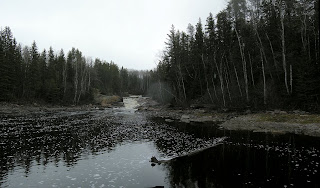
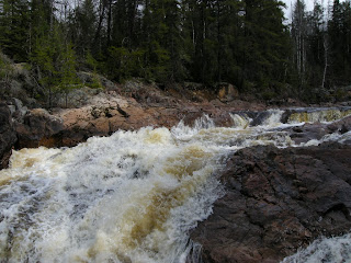
Photo by Markus
This Area may soon Disappear, if not for Your Help!
If this place looks familiar … Read on
A proposed HydroElectric development will drastically change High Falls on the Grassy River. The scenic beauty of these rapids and waterfall, only 23 km from downtown Timmins, will be lost forever as the river flow is forced into a large pipe to feed the turbine and generator. The falls, as we now know it, will cease to exist. The preliminary work has already started as an environmental screening process is now happening. Public input will be sought probably in early Spring 2008 or 2009 or 2010 or 2011 or 2012 - Who knows ?
If you want to do something about it or want more information please Email: GrassyRiver@gmail.com
High Falls Background Information Link
Google Map/Panoramio Showing Area of the Proposed Dam
Click for Google MAP
Send Us Your pictures and they will be included on the blog
Email pics to: GrassyRiver@gmail.com
Jun 29, 2008
Jun 27, 2008
Jun 26, 2008
Jun 25, 2008
Jun 24, 2008
Jun 23, 2008
Jun 22, 2008
Jun 21, 2008
Jun 20, 2008
Jun 19, 2008
Jun 18, 2008
Jun 17, 2008
Jun 16, 2008
Every River in Canada is Now Threatened
As if we didn't have enough to fight to protect rivers. Now the
federal government seems to be against us.
Incredible as it may seem, the Harper government is considering the
elimination of the historic right of public navigation in Canada.
A good website to see what is happening is
http://www.canadianrivers.net/index.html
Posted by Markus at 11:59 p.m. 0 Click to Leave Comments
Jun 14, 2008
Jun 13, 2008
Jun 12, 2008
Jun 11, 2008
The Romaine River Located in Quebec
Another Group in Quebec Fighting to Save a River
Alliance Romaine
Safeguarding the future of the Romaine River
Please join us in asking Quebec to protect its natural heritage! Let’s say “No thanks!” to more hydroelectricity and save the Romaine River.
The Romaine River, situated north of the municipality of Havre-Saint-Pierre in Basse-Cote-Nord, is one of Québec’s last large undammed rivers. Hydro-Quebec plans on building a 1550 MW hydroelectric complex composed of four dams which would produce close to 8 TWh of electricity per year.
Visit the Alliance Romaine Site for more details
Posted by Markus at 4:48 p.m. 2 Click to Leave Comments
Jun 10, 2008
Jun 9, 2008
Jun 7, 2008
Jun 6, 2008
Jun 5, 2008
Pic of the Day
Could you just picture canoeing down here ?? :-) or kayaking
Photo by Markus
Posted by Markus at 8:00 a.m. 0 Click to Leave Comments
Jun 4, 2008
Jun 3, 2008
Jun 2, 2008
Pic of the Day
This shot taken just down river from the falls
Photo by Markus
Posted by Markus at 4:29 p.m. 0 Click to Leave Comments
Jun 1, 2008
Pic of the Day
east of yesterday's pic
This river has many secrets - let's hope they aren't lost
If you want to know where it's located then email me at grassyriver@gmail.com
Photo by Markus
Posted by Markus at 8:10 a.m. 0 Click to Leave Comments


